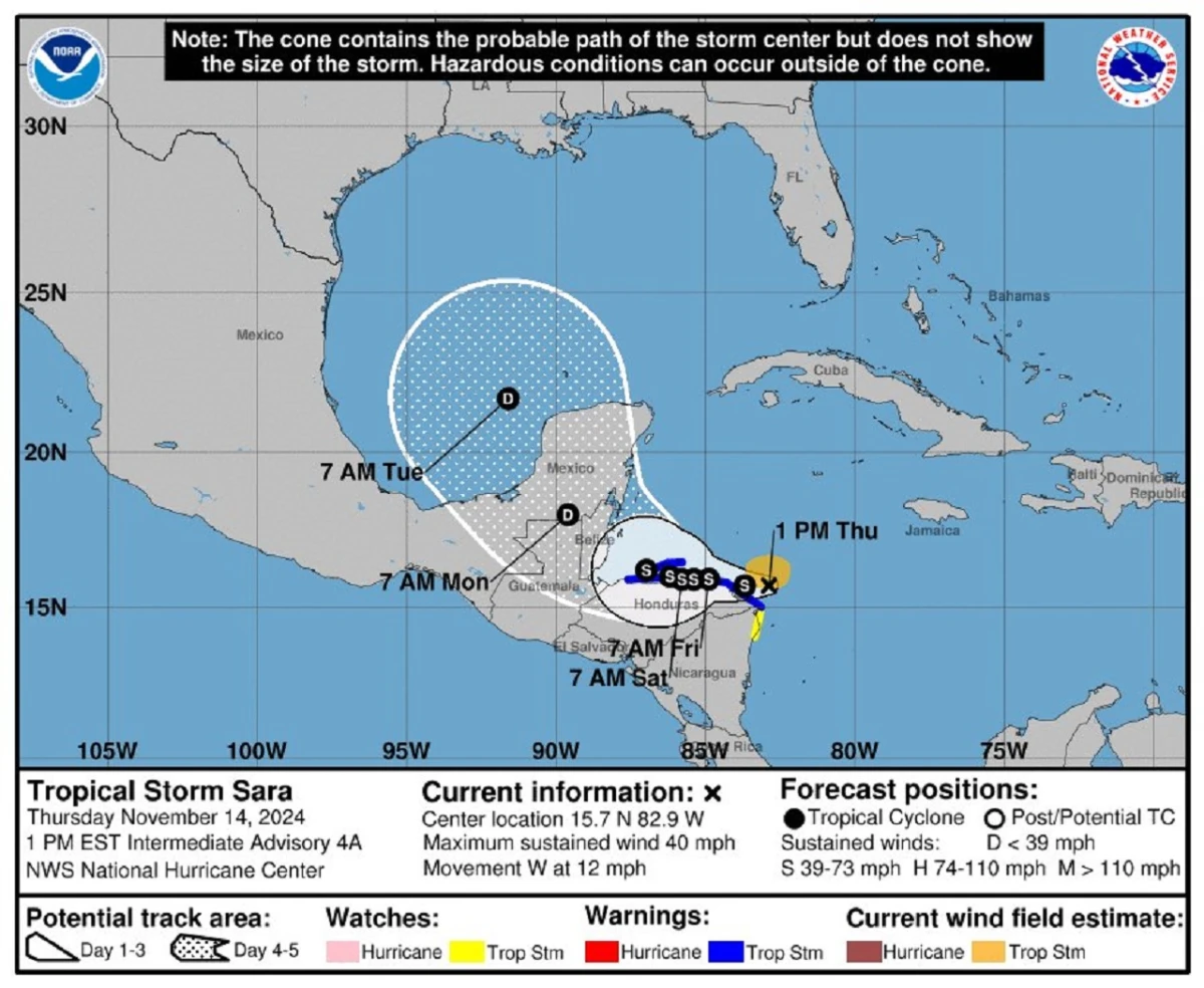
Tropical Storm Sara emerged this Thursday off the coast of Central America and near the southeast of Mexico, reported the Mexican National Meteorological Service (SMN), which predicts that the phenomenon makes landfall at night in Honduras.
>>>Read also: Why did Wednesday’s landslide occur in the hills of Bogotá and in which other areas is there a risk?
In the last report, the cyclone was 330 kilometers east-southeast of Guanaja Island (Honduras) and 610 kilometers east-southeast of Puerto Costa Maya, in Quintana Roo, a state in the Mexican Caribbean. And according to the US National Hurricane Center (NHC), Sara threatens Honduras with “potentially catastrophic” flash floods and landslides.
>>>Read also: What is known about Tropical Depression 19 and what effects would it have in Colombia?
Follow details of the tropical storm’s path here.
9:10 p.m.
The UNGRD of Colombia reports that Tropical Storm Sara, located in the northwest of the Caribbean Sea, continues to influence weather and sea conditions in the Archipelago of San Andrés, Providencia and Santa Catalina and indirectly in La Guajira.
“The phenomenon could continue to cause intermittent rainfall of varying intensity in the area of the Archipelago of San Andrés, Providencia and Santa Catalina, including its maritime area, where winds between 18 and 37 km/h and waves between 0.5 and 1.6 meters are estimated, therefore For this reason, the alert status is degraded from enlistment to notice,” reads the most recent statement.
8:45 p.m.
In Honduras, in the cities of La Ceiba, department of Atlántida, and Roatán, Bay Islands, their international airports were closed due to the rains, which are already causing floods, landslides and downed trees, among other damages, according to reports from local authorities.
8:30 p.m.
The Honduran president, Xiomara Castro, said today on the social network a catastrophic event. “Citizens must be attentive to the instructions and move to safe shelters, away from rivers,” adds the president’s message.
8:00 p.m.
The rains have intensified in northern Honduras due to the slow movement of tropical storm Sara that formed this Thursday in the Caribbean, official sources in Tegucigalpa reported.
The rainfall most intensely affects eight departments of the country, five of them in the Caribbean, one in the north, one in the west and another in the east, which have been declared in preventive alerts and mandatory evacuation.
According to sources from the Secretariat of Risk Management and National Contingencies (Copeco), the phenomenon is moving off the Honduran coast in a westward direction, and due to the slowness it shows, it could leave the country between Sunday and Monday, leaving rainfall. that will cause rivers and streams to overflow, and floods, among other damages.
3:45p.m.
The UNGRD of Colombia reports that the evolution of Sara has favored the development of rains with storms and gusts of winds in sectors of the western and central Colombian Caribbean Sea, reaching speeds of between 16 and 37 km/h and waves of 0.5 to 1 .6 meters from the southwest.
It is expected that The storm continues to influence the weather and sea conditions in the region, with intense rain, gusts of wind and an increase in wave height, Therefore, the enlistment alert is maintained for the Archipelago of San Andrés, Providencia and Santa Catalina.
“This system, in interaction with local dynamics, can favor rainfall in the department of La Guajira and areas adjacent to the Sierra Nevada de Santa Marta, so the warning alert is maintained,” the statement reads.
The rest of the coast remains under surveillance due to a possible increase in the magnitude of the wind and changes in the direction of the waves.
Maritime authorities recommend following precautions in nautical activities and in the movement of vessels in the area.
UNGRD
3:30 p.m.
NHC meteorologists, based in Miami, Florida, indicated in their most recent bulletin that Sara has maximum sustained winds of 65 kilometers per hour (40 miles) and is moving west with a forward speed of 19 kilometers per hour (12 miles)..
According to the forecast trajectory, the system will continue moving westward this Thursday and its center will pass near the east coast of Honduras. The Government of Honduras maintains a storm warning for the north of the country’s coast, from Punta Sal to the east to the border with Nicaragua, and from Puerto Cabezas to the north. The system is expected to continue strengthening, if it remains over the sea.
Source: https://www.noticiascaracol.com/mundo/tormenta-tropical-sara-en-vivo-siga-aqui-su-trayectoria-se-mantiene-alerta-en-san-andres-rg10


